AppScoutAppScout.gallery
GLand: GPS Field Area Measure icon
Utilities

GLand: GPS Field Area Measure

by Authai Yaprasat
Rating4.6(593)
PriceFree
Updated1mo ago
Released3y ago
Latest rank
Not tracked yet
Rank change
Not tracked yet
Rank history
Movement appears after the next data refresh.

Screenshots

GLand: GPS Field Area Measure screenshot 1GLand: GPS Field Area Measure screenshot 2GLand: GPS Field Area Measure screenshot 3GLand: GPS Field Area Measure screenshot 4GLand: GPS Field Area Measure screenshot 5GLand: GPS Field Area Measure screenshot 6GLand: GPS Field Area Measure screenshot 7

ASO analysis

Title29 / 30
GLand: GPS Field Area Measure

Tight against the limit — verify it doesn't truncate on small screens.

Description1,221 / 4,000
6 paragraphs · 31% of limit used

Could go longer. The first 252 chars are above-the-fold; everything else still indexes.

Top keywords in your description
area×4layers×3measurement×3support×3calculations×2easily×2estate×2geojson×2land×2length×2map×2measuring×2
Keyword opportunities

Used by similar apps in your niche, but not in your title or description. Adding these (where genuinely relevant) can broaden your search reach.

measurements6 peersplace6 peersaccount5 peersfeatures5 peersleast5 peersprivacy5 peerstape5 peersaccess4 peersadvanced4 peerscharged4 peers
Shared niche keywords

Words you and your peers both use. Confirms positioning in this niche.

measure8 peershttps7 peersarea6 peersmeasuring6 peerstool6 peersautomatically5 peerscom5 peerscurrent5 peersfree5 peersmeasurement5 peers

Keyword rankings

iTunes Search · top 200
Keyword tracking starts automatically for apps on the top charts — ranks appear after the next data refresh. Manual tracking for search-only and niche apps coming soon.

About

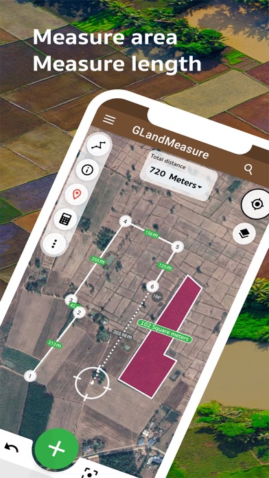
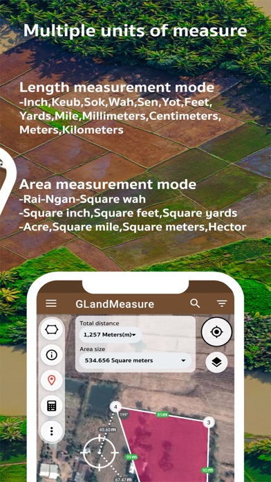
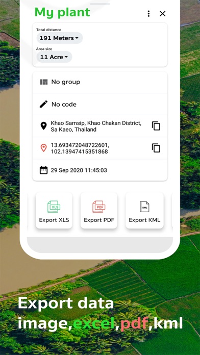
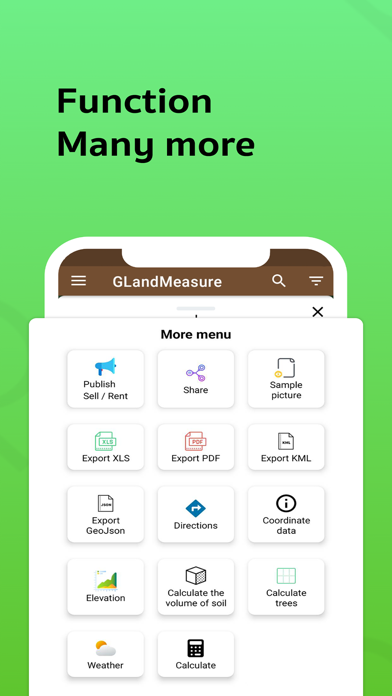
GLandMeasure is a free app for measuring areas and lengths that can be used to measure land, farm, field, home, distance, and length measurement easily. With the method of pinning on the map Or use the actual walking method Which the app will calculate the area And length automatically You can also choose from several types of measurement units. And can also be able to easily share images of the area Just a few steps It covers the use of people who work in real estate as well. Including farmers who want to use it, it is considered an answer. After measuring the area, you can export your coordinates in a variety of formats, such as land sales announcements. Real Estate Society, PDF, Excel, KML, Geojson, map photos, route finder, elevation, soil cue calculations, tree counts in area, weather forecasts, calculations and cameras. Support various tools compass tool convert measurement units Coordinate unit converter GEO(Lat Long) UTM MGRS Geojson geographic camera Supports multiple layers: WMS, XYZ Tiles, Image Layers, Current Rain Layers. Support to create multiple projects Support for displaying large amounts of data Terms of Use: https://www.apple.com/legal/internet-services/itunes/dev/stdeula/

01
GPS Fields Area Measure icon
GPS Fields Area Measure
Rento UAB
4.6
02
GPS Fields Area Map: FieldCalc icon
GPS Fields Area Map: FieldCalc
Pravin Gondaliya
4.6
03
AR Plan: Room & Floor Measure icon
AR Plan: Room & Floor Measure
Grymala sp. z o.o.
4.5
04
Measuring Tape+ Measure AR app icon
Measuring Tape+ Measure AR app
MEASURE TECH SOCIEDAD LIMITADA
4.5
05
Tape Measure™ icon
Tape Measure™
Level Labs, LLC
4.4
06
Tape Measure+ AR Digital Ruler icon
Tape Measure+ AR Digital Ruler
MEASURE TECH SOCIEDAD LIMITADA
4.4
07
MyMeasure icon
MyMeasure
Pendlebury Software LLC
5.0
08
Tape Measure Calculator Pro icon
Tape Measure Calculator Pro
Bugfoot Studios LLC
4.9
09
MeasureBetter icon
MeasureBetter
TEN3 Software LLC
0.0
10
GPS Navigation and GPS Maps icon
GPS Navigation and GPS Maps
Hoang Hang
3.4