

RemoteFlight MAP
Screenshots

ASO analysis
Good use of the title field.
Could go longer. The first 252 chars are above-the-fold; everything else still indexes.
Used by similar apps in your niche, but not in your title or description. Adding these (where genuinely relevant) can broaden your search reach.
Words you and your peers both use. Confirms positioning in this niche.
Keyword rankings
iTunes Search · top 200About
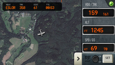
RemoteFlight MAP is an ideal companion for long haul flights in Flight Simulator (FSX /FS9/P3D) or X-Plane, as well as a tool for those, who like to explore the world while flying. Zoomable vector or photoreal map moves with the aircraft and key flight variables are displayed on side-panel, which you can hide. You can choose from different types of maps, aircraft icons and units of measurement. Now you can sit back and relax, or chat with a stewardess, while still fully aware of the situation in cokpit. Please note, that this app is intended for Flight Simulator enthusiasts and cannot be used to track real flights. [Key Features] • Fast updates of key flight variables (interval configurable) • Indicated Airspeed and Groundspeed • Altitude • Magnetic heading and real track heading (based on GPS) • Climb / Descent indication • Flight plan display (in Windows only) • Fullscreen map mode with minimized panel • Configurable aircraft icon - airliner, general aviation, helicopter or a simple arrow • Configurable units - feet/knots or metres/kph RemoteFlight Server utility is required to establish the connection between Flight Simulator and your device. RemoteFlight server is very lightweight and will not affect the performance of your Flight Simulator. Download the server free on https://www.remoteflight.net/server We also have a native plugin for X-Plane users on OSX system.